
note
MAPPING BLAKE’S LONDON
When Karen McHaney and I began working on maps for the Norton Critical Edition of Blake in February 1976, neither of us knew what we were getting into. Karen, a professional cartographer who happens to be a close friend of mine, expected to do precision work; I had in mind a visionary map making use of the northern and southern “gates” in Milton 28 [K 26] and the miniature skylines of York and London in Jerusalem 57, perhaps outlining Albion’s sleeping body against the cliffs of Dover. I thought we could distort the scale along the lines of “A New Yorker’s View of the U.S.A.,” which shows the Hudson River about where the Mississippi should be and the rest of the country a shrunken blur, except for San Francisco, Los Angeles, and Miami Beach. The only example I had on hand to give Karen was a non-scale tourist map of London which contains blow-ups of the main attractions. It turned out, however, that Karen’s insistence on true scale forced me to a better understanding of the physical spaces in Blake’s visionary universe which I believe will make certain geographical relationships clearer to others than can be determined from previously existing maps.
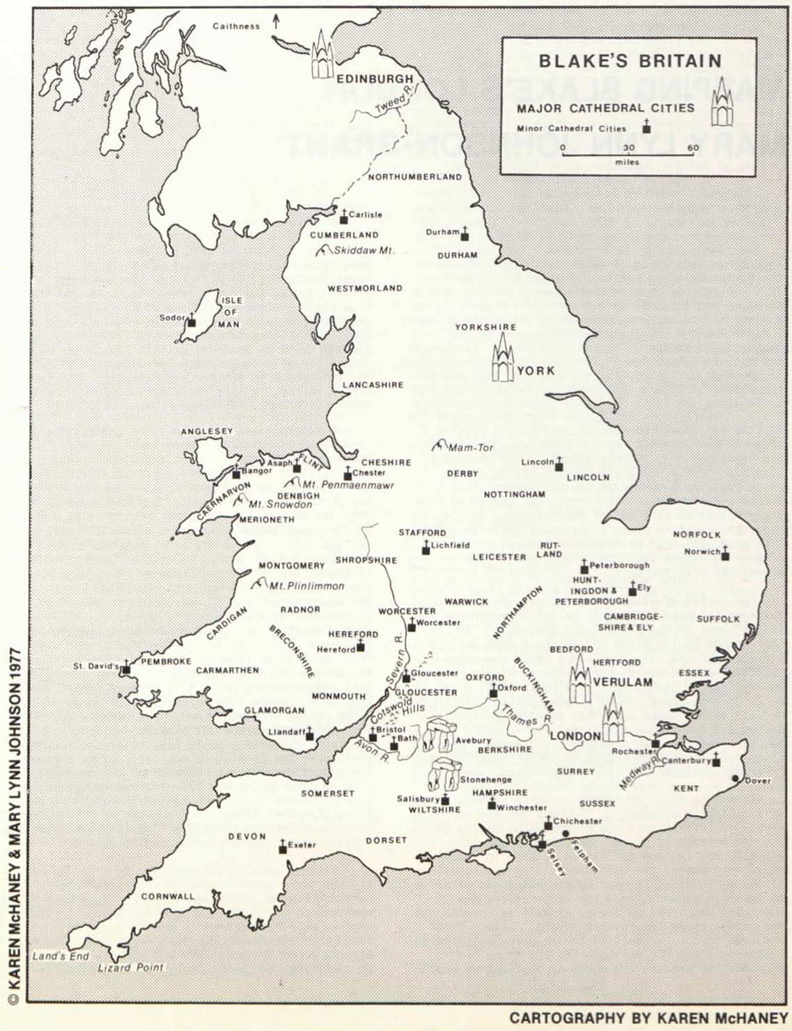
We worked first on the Holy Land and Britain, thinking it would be a cinch to put together the maps in the backs of our Bibles with Stevenson’s map in the Longman-Norton Blake and to check both against Blake’s biblical allusions. But Bible maps show political boundaries at particular points in history, and the map in Stevenson’s edition (p. 575, drawn by K. C. Jordan) doesn’t make a typographical distinction between tribal names and other territories such as Bashan and Moab; also the tribal territory of Simeon has been omitted. We combined place-names from all historical periods to represent Blake’s overlaying a Christian outlook upon this ancient land. When the authorities were uncertain or in conflict about the location of a city, we placed it where it seemed best to fit Blake’s references. To keep the map uncluttered, we left out all places important in the Bible but unimportant in Blake. We followed the same practice for the map of Britain, adding to Damon’s Dictionary map of the cathedral cities the locations of the 52 counties (a meaningless catalogue of names to American students) and the major rivers and mountains mentioned by Blake, as well as Felpham and the landmarks in the southern “gate,” Lizard Point and Land’s End. We settled for an arrow pointing to Caithness along the northern “gate”; if we had extended the area to the north of Scotland we would have had no space for the names of the counties, after reduction to fit the map on the Norton page. Our effort to draw something resembling both the coastline of Britain and the Giant Form of Albion came to nothing; perhaps some one person knowledgeable in Blake and skilled in cartography, calligraphy, and drawing could do better. We left Albion and Jerusalem to the viewer’s imagination and suggested the visionary dimensions of Britain and Palestine by Stonehenge-like trilithon markers for places associated with human sacrifice, including Golgotha and Tyburn.
Making the London map was the hardest, yet most rewarding, of our jobs. Our chief innovation has been to represent all places important to Blake, in both his life and his work, during all periods of his career. Thus we could not base our map on any single historical map. Stevenson’s “Map of London ca. 1810” requires an explanatory note: “The site of Regent St. is approximately that of Swallow St. on this map” (p. 621), and in any case it takes in so much territory that it had to be reduced beyond the point of legibility to fit on the page. Nor could we depend upon the portion of Cary’s “Plan of London and Westminster” (1820) reproduced in Damon’s Dictionary—helpful though it was to us—because the Blake locations don’t stand out among all the other features; also it doesn’t extend far enough east into The City to show St. Paul’s and London Stone or far enough north to show Regent’s Park. Until the last stages of our project, I somehow forgot about Bentley’s reproduction of portions of Horwood’s “Plan of the Cities of London and Westminster” (1792-99), which points out all Blake’s residences; without Bentley’s guidance I would have misplaced Fountain Court near the Temple, on the basis of an erroneous guidebook description. Because of the combined effects of photographic blurring and reduction, the name of Fountain Court in Bentley’s reproduction is illegible; this street is not shown at all in Damon’s clear reproduction of Cary’s Plan (it should be about where the “46” is, west of Waterloo Bridge).
Because we were not confined to a London map of any one year, we were able to represent “eternally building eternally falling” London: John Nash’s renovations (1812-20) and Waterloo Bridge (originally planned as Strand Bridge). Here I began to understand what the Golden Builders were doing. We had already found Willan’s Farm and the Jew’s-Harp House on early maps of London before Blake’s time; in begin page 118 | ↑ back to top
![Gethsemane Mount of Olives
Golgotha Temple
Herod’s Palace
JERUSALEM
0 miles .5
Sidon Mt. Lebanon Damascus
LEBANON Mt. Hermon ARAM (SYRIA)
Tyre
OG
Hazor
ASHER BASHAN
NAPHTALI Sea of Galilee
[Land of Cabul]
ZEBULON Ashteroth
MEDITERRANEAN SEA
Mt. Carmel Kishon Richer Nazareth Manasseh
ISSACHAR
MANASSEH GAD
NORTHERN KINGDOM
Tirzah Jordan River
Mt. Ebal Mahanaim
Shechem Succoth Jabbok River GILEAD
Kanah River Mt. Gerizim
Adam AMMON
Shiloh
EPHRAIM Zaretan Rabbath
DAN
SIHON
Jericho
BENJAMIN Gilgal
CANAAN Mt. Peor Heshbon
Jerusalem Mt. Pisgah
Bethlehem
PHILISTIA Gath
JUDAH REUBEN
SOUTHERN KINGDOM
Hebron DEAD SEA Arabian Mts. Arnon River
Gaza
SIMEON
Beersheba
AMALEK
MOAB
EDOM
[IDUMEA]
SINAI Deserts of MIDIAN and Mt. Horeb
THE HOLY LAND
Tribal names . . . . . . . . JUDAH
0 15 30
miles
© KAREN McHANEY & MARY LYNN JOHNSON 1977
CARTOGRAPHY BY KAREN McHANEY](img/illustrations/HolyLand.10.4.bqscan.png)
![BLAKE’S LONDON
1757-1827
0 ¼ ½
miles
to HAMPSTEAD to HIGHGATE
Primrose Hill Pancras Work House
ST. JOHN’S WOOD [REGENT’S PARK] GREEN LANE PANCRAS
New Small[p]ox Hospital
Willan’s Farm Jew’s-Harp House
NEW ROAD FROM PADDINGTON TO ISLINGTON
PADDINGTON MARYLEBONE
Work House Green Men FITZROY SQ. Foundling Hospit[a]l
Thomas Butts’ House after 1808
EDGWARE ROAD MARYLEBONE LANE PORTLAND PL. [REGENT ST.] TOTTENHAM CT. RD.
Tyburn STRATFORD PL. Butts’ House in Gt. Marlborough St.
TYBURN ROAD OXFORD STREET BROAD ST.
S. MOLTON ST. POLAND SOHO SQ. Basire’s Hou[s]e
GROSVENOR SQUARE NEW BOND ST. Carnaby Mkt. BROAD
School of Industry GOLDEN SQ. LEICESTER SQ. ST. MARTIN’S LANE DRURY LANE
HYDE PARK Tyburn Brook Pars’ Drawing School Fountain Court
KENSINGTON GARDENS PICCADILLY PALL MALL GOLGONOOZA
KENSINGTON RD. KNIGHTSBRIDGE GREEN PARK THE MALL WHITEHALL
to HOUNSLOW
Buckingham Palace ST. JAMES PARK
BIRD CAGE WALK GT. GEORGE ST. WESTMINSTER BRIDGE
JAMES ST. Westminster Abbey Parliament
Dacres Alms House
Green Coat School Lambet[h] Charity School
KINGS ROAD ROCHESTER ROW Grey Coat School HORSEFERRY RD. Lambeth Palace
Royal Military Asylum
RANELAGH GARDENS
Chelsea Hospital VAUX[H]ALL GAR[D]ENS
CHELSEA [VAUXHALL BRIDGE]
RIVER THAMES
BATTERSEA ROAD
CHELSEA BRIDGE
BATTERSEA
UPPER STREET LOWER STREET
ISLINGTON
CITY ROAD HACKNEY ROAD
GRAY’S INN ROAD OLD STREET RD.
RED LION ST. [Sutton’s] Charterhouse School Bunhill Fields
ALDERSGATE ST. FINSBURY PL. BISHOPSGATE ST.
HOLBORN Christ’s Hospital [Blue Coat School]
[L]INCOLN’S INN FIELDS Bethlehem Hospital [Bedlam]
Newgate Prison
[T]HE STRAND FLEET ST. CHEAPSIDE WHITECHAPEL ST. MILE-END and “OLD BOW”
St. Paul’s
Somerset Hs. Royal Acad. WATLING ST.
Joseph Johnson’s Bookshop London Stone
WATERLOO BRIDGE BLACKFRIARS BRIDGE
LONDON BRIDGE The Tower
BLACK FRIARS ROAD St. Thomas Hospital TOOLY STREET POPLAR
A[stl]ey’s Royal Amphitheatre Guy’s Hospital
He[rc]ules Bldg. BOROUGH ROAD LONG LANE [I]SLE OF DOGS
Asylum for Female Orphans BLACKMAN STREET
LAMBETH ROAD
New Bethlehem Hospital
CAMBERWELL ROAD OLD KENT ROAD
BLACKHEATH and SHOOTER’S HILL
CLAPHAM ROAD
CAMBERWELL PECKHAM RYE
© KAREN McHANEY & MARY LYNN JOHNSON 1977
CARTOGRAPHY BY KAREN McHANEY](img/illustrations/BlakesLondon.10.4.bqscan.png)
A few other features are noteworthy: Blake’s patron Thomas Butts, usually thought of as residing in Fitzroy Square, did not move there until 1808; we have marked also his house in Great Marlborough Street, to which Blake addressed his correspondence. By leaving out streets and landmarks inessential to Blake’s London, we were able to show places associated with his training and career as an artist-engraver: Pars’ Drawing School, James Basire’s house and engraving shop in Great Queen Street, the Royal Academy in Somerset House, Joseph Johnson’s bookshop in St. Paul’s Churchyard; if I had thought of it we might have put in Langford’s sale-rooms in Covent Garden. We included prominent orphanages, hospitals, and workhouses which must have been important in Blake’s vision of London whether or not he names them. One of these is the Charterhouse School, the institution for “aged men and youth” in Obtuse Angle’s song “To be or not to be” from An Island in the Moon; this and other charity schools on our map can be imagined as those from which children in red and blue (Christ’s Hospital) and green (Green Coat School) marched to St. Paul’s, and perhaps Dacre’s Alms House is where little Tom Dacre lived before he was sold to the master chimney sweeper. An idle query of no scholarly significance: as there is no North Molton Street, was South Molton Street named after the Devonshire village of South Molton? Books on the origin of London street-names don’t answer the question.
Working on these maps has helped me visualize the building of Golgonooza amid the soot and clamor of London. Place-names associated with Blake are easier to spot than they are on other readily available maps of late eighteenth-century and early nineteenth-century London. I hope all three maps will be useful to readers of the Blake Newsletter, as well as to the students who will read William Blake: Selected Poems and Designs, a Norton Critical Edition edited by John E. Grant and Mary Lynn Johnson, scheduled for publication in the winter of 1978.